Thursday, 23 February 2012


Have you seen the new BBC1 series about British landscapes? If not, they are worth watching. Here is the link for the first episode shown last week which covers Cornwall and Devon
http://www.bbc.co.uk/iplayer/episode/b01c9wdv/The_Great_British_Countryside_Cornwall_and_Devon
The second, on Yorkshire was shown this evening and will be available soon on BBC iPlayer.
It looks like a series worth sticking with if you want to understand our landscapes and the way they have shaped us as a nation. 

Friday, 3 February 2012

Jammin' in Torquay


In the seafront gardens

Thursday 2nd February.......
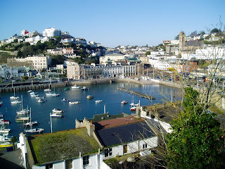
Today the sun shone in the sky from the moment the day arrived. A good day to visit Torquay, the Jewel of the English Riviera, a place which attracts people from all over Britain.
Listening at the harbour

The first mission was to map the land use of the central area of the town looking for uses such as shopping, recreation and being a resort, hotels. The count of pedestrians allowed us to discover the inner centre of the town, the busiest place, probably. Questionnaires were the most interesting part, because having someone else's perspective is very useful to find out how the town may have changed (if you are asking a local) or if the changes are have enhanced entertainment (if you are asking a tourist).
Torquay and its harbour
After a quick break for lunch (turkey sandwich at Torquay, ha ha), it was time to analyse the Goad maps. Goad maps are high detailed maps showing all the shops of the city/town. The analysis showed that some chain stores were still there after 20 years and some independent shops were substituted by other chain stores or restaurants.
Torquay, being known as a holiday resort makes it an attractive place right from the start and from what we saw it's still doing that job today.


Sara and Vikas

Watch this You Tube clip


Torbados by locals, written by Hoodie BigCol , performed by LadyV.
It is a parody of Alicia Keys' song and paints quite a different view of Torquay.

Thursday, 2 February 2012

Arctic Winds on the Devon Coast

Wednesday 1st February.........
Freezing at Start Point

We were looking forward to a nice long stroll along the coast. If it wasn't for the arctic winds,  we would have had that! We started at the aptly named Start Point, and shivered in a -5C wind chill factor while we posed for the group photo.
Hallsands ruined village
First stop was at Hallsands, a ruined village which was destroyed in 1917 by the mismanagement of the fragile coastline. The shingle was dredged from the bay to make concrete for the expansion of Devonport Dockyard in Plymouth. Sir John Jackson who was commissioned to build it, failed to understand how the sediment cell in Start Bay functioned. Consequently, the beach in front of Hallsands disappeared in a matter of years, leaving the village to face the brunt of the North-easterly winds.
Beesands village showing different types of coastal defence.

Further up the coast, the engineering constructed to protect the village of Beesands was examined. Sea walls, gabions and rip-rap are used extensively for this purpose. We used a variety of methods, including bi-polar and cost-benifit analyses to determine the effectiveness of the defence schemes. A do-nothing scheme north of Beesands was also implemented where the land is not worth the expense of protecting. This allowed us to contrast the effects of these coastal defences.  Further to the north, similar methods were used in the village of Torcross, except on a much larger scale, because of a violent storm that hit in January 1979. Finally, we looked at shingle bastions, which are a more sustainable way of protecting the coastline.
Stone sampling
Torcross with its sea-wall


Despite the bitter, ice cold winds, and the relief of being back at the field centre, which never seemed more inviting, it was a very worthwhile day.


With the memorial Sherman tank in Torcross
Ashley & Anthony

Tripping out in Totnes

Tuesday 31st January..........

In Totnes Town Hall Square
 Countryside has its problems too you know? So the question is what to do? Making a success out of a market town which is going through a period of transition. The day started with a bumpy journey to the transition town Totnes, courtesy of some excellent driving. We explored the town and some of the strategies used to rebrand it. The 'Incredible Edible' which was a herb garden in the street planter next to the Steamer Quay. It was interesting to see and taste the variety of herbs and salad leaves, bringing the community closer to where their food is grown and encouraging the people to participate in community activities.
All at sea with Caterham Geographers


 Small businesses trying to keep the cash flow within the town, started up their own currency called the 'Totnes Pound'. Interviews with local traders suggested that the currency was used by tourists as well as locals. However by interviewing the general public we found that it was not used in all shops which made accessibility to the currency hard. We all found Totnes to be a unique town and a general welcoming which shows a sense of community.
Incredible edibles - community food supply in Totnes.

 The day finished with a visit to Riverford farm which has grown from a local farm into a national organic supplier. We looked inside the shop and tried to compare the goods to those in Totnes. Riverford supply a wide variety of local produce available through its vegetable delivery scheme. Overall we learnt that rebranding can vary from place to place and can itself create challenges for the communities involved.

This video explains the way Totnes involves its inhabitants in the transition town way of living.

Darren and Hassan

Eight go Wild in Plymouth.

Eight go Wild in Plymouth.
Ready for the off.
Monday 30th January....
Rain. Rain. RAIN!! blurgh :(
The day starts with a warm shower, challenged by the cold outside.  A quick brief told us where we would be heading today. Destination: Plymouth
The forty five minute drive with a driver who is.. well... hmmm.. not bad :S
First stop: The Hoe
A red and white lighthouse stands on the green where Sir Francis Drake continued to play bowls despite imminent approach of the Spanish Armada.

Here, surrounded by the history, we studied the events which made Plymouth such an important city.

Second Stop: Frankfort Gate and the Covered Market. Here, we assessed the attempts to rebrand this part of the city centre by creating an independent quarter. We assessed this by using Environmental Quality Index, Index of Decay, Pedestrian Count and Perception Study.

Third stop: Drake Circus; using the same techniques, we assessed the success of this most modern addition to Plymouth's retail landscape. This under cover shopping precinct contrasts starkly with the closed shops fourth down the hill in the city centre.


Drake Circus shopping centre

Empty retail space in the city centre.

Fourth Stop: The Historical Barbican District, site of the Mayflower steps whence the Pilgrim Fathers are said to have departed for a new life in the New World.
An interesting area full of potential which was dampened by the dismal weather.

Running from the Urban Splash cows
Ahoy there!
Last stop: Royal William Yard, an exciting new developed by Urban Splash, which is bringing modern loft-living to a historical complex of buildings which was once the Royal Naval Victualling Yard.

The End.
Charlotte and Jordan, Caterham Geographers